Leaders: Dianne and Bob Machesney (412) 523-0368. diannem15237@aol.com
If thunderstorms are predicted. Call Dianne to verify.
Bring a lunch for after the hike. There are picnic tables available in a roofed shelter.
Directions From Pittsburgh: take I-79 North to Exit 99, New Castle/ Butler. Drive east on Route 422 roughly 5.8 miles to the Prospect Exit. Turn left (north) onto Route 528.
Continue on Route 528 for about 7 miles. Meet in the Jennings Prairie Parking Lot on the left (west) side of the road.
We have not been to the EFNA this early in quite a while. This is a flat, game lands road/trail.
Directions: There are many ways to get to EFNA; if you have never been there, use the GPS coordinates 39.96107, -80.4627 with smartphone maps ahead of time. EFNA is located at the end of Smokey Row Rd in PA State Game Lands 302. The directions below are not the most direct, but the simplest.
Take I-79 south to Exit 14 Waynesburg. Turn right at end of ramp and travel PA 21 west for 19 miles through Waynesburg and Graysville. About 2.5 miles from Graysville, make a right onto Nebo Ridge Road (there is a farmhouse here on the right with stone siding ).
Follow Nebo Ridge Road for 2.8 miles. The road will make a sweeping curve to the left and you’ll come to a group of houses (old cars and junk lying around). Turn right onto unmarked Walker Hill Road at a sign for RHL 28. Continue about 1/4 mile, make a sharp left onto Smoky Row Lane, at a sign for state game land; follow that down the hill, through an S curve at the mine conveyor facility, then onto Enlow Fork. Go as far as you can go till you come to a gate and parking lot. Do not stop at the first lot on the left or you’ll have a few hundred yards of walking to do.
Rain or shine, for a leisurely paced, easy walk. Come early, 11:30, for lunch, 12 noon for start of walk. Meg is willing to transport 5 people in her mini van. Meet at the North Park Ice Rink/Basketball Courts on Kummer Rd at 10:45 AM.
Directions: From Pittsburgh take I-79 north to Exit 105. At the end of the ramp turn left on PA 108. Travel east on PA 108 for about 0.7 miles to West Park Rd (Dairy Queen on the right). Turn left onto West Park Road (SR 1015) and drive north about 1.8 miles to SR 1020 (you can see some large silos on the right). Turn right on SR 1020 (Miller Rd) and drive about 1.7 miles to the small parking lot on the right. (SR 1020 is a winding road and at an almost T intersection, turn right to stay on SR 1020.) If you reach the bridge, you have gone too far. The parking lot is just before you reach the bridge over Wolf Creek.
Arrive at 11:30 AM to eat lunch, weather permitting. No restroom facilities. We will start walking at 12 noon.
May 8, 1915 is 109 years, 11 months and 1 week from April 19, 2025. Spring comes much earlier, but the Botanical Society is still a strange looking company in knock-about clothes. Let’s see if we can beat 115 plants recorded by the 1915 MArvels of Roaring Run troop. Leader: Loree Speedy ; 724-518-6022
We will meet at the parking lot along the river and carpool to the smaller Rock Furnace lot upstream of Roaring Run for a hike of 3 miles, mostly downhill and along the river.
Directions: From Pittsburgh, take I-376 Parkway East and continue on US 22 east for 1.5 miles to PA 286 (Golden Mile Highway). Continue on PA 286 – it will become PA 380 after the commercial development and Dairy Queen. Continue on PA 380 to PA 66 and travel PA 66 north (right at end of ramp) to Apollo. Cross the bridge into Apollo and turn right at the traffic light immediately after the bridge onto Kiski Avenue. Follow this road through the town about 0.8 mile until a fork; take the right fork onto Canal Road. The road dead-ends at the Roaring Run trailhead parking lot. We will meet here.
Leader: Shane Miller, Environmental Educator at Raccoon Creek State Park
Let’s join member and botanist Shane Miller for a trip through one of the most diverse populations of plants in the state. Be prepared for wet trails and moderate hiking.
Directions: From Pittsburgh, take the Parkway West – Route 376 west (former Route 60 north) to Exit 52, Clinton (one exit past the Airport). At the end of the ramp, turn left and continue 1.1 miles to US 30. Turn right onto US 30 and drive 4.7 miles to the entrance for the Wildflower Reserve, on the right, just over a hill.
Hells Hollow Trail, McConnells Mill State Park, Lawrence County
The half-mile trail leading to a waterfall is easy hiking. Those who wish to continue should wear sturdy shoes.
Directions: From Pittsburgh, take I-79 north to Exit 96 – Portersville. Turn left to travel PA-488 about 4 miles to Heinz Camp Road. Turn right onto Heinz Camp Road and continue about 2 miles to a T. Turn right and cross the Armstrong Bridge. Continue up the hill about 2 1/2 miles and make a right onto Shaffer Road. The Hell’s Hollow Trailhead parking lot is on the right about 100 yards after the turn, just before a one-lane bridge.
Leader: Lindsay Praksti, Westmoreland Botanical Society
O. E. Jennings, in the gazetteer of his 1953 Wild Flowers of Western Pennsylvania and the Upper Ohio Valley, called this area “good botanizing ground” with woods, marsh and a stream that flows through a deep gorge. We will join the Westmoreland Botanical Society.
Directions: From Pittsburgh, take the PA Turnpike to Exit 91 – Donegal. Turn left on PA 31. Travel about 2 miles and turn right on PA 381 at the traffic light. Travel about 11.5 miles on PA 381. Once you cross a bridge over Mill Run Reservoir, look for a Camp Christian sign and turn right onto the next unpaved road. At the Y, turn right and continue to a trailhead parking area.
Gabrielle has a good feeling about this beautiful valley of the Browns Run tributary to the Monongahela River. As we enjoy rich diverse slopes of paw-paw, we will look for the Zebra Swallowtail.
Directions: From Pittsburgh, take I-79 south to Exit 14. Turn left to travel PA21 east. Continue 21 miles to the Exit for PA 166 South. Turn right at the end of the ramp. Travel 1 mile north on Ronco Road. Bear right at the Y onto Shortcut Rd (unmarked). Continue 0.3 mile to trail parking on the right.
We will meet at the new Visitor Center along US 22. We will walk the Funk Bikeway and then some narrower hilly hiking trails along Fernwood.
Directions: From Pittsburgh, take I-376 east (Parkway East) to its end at US 22 East – Murrysville. Travel US 22 for about 4 miles to the intersection of Trafford Rd (McDonald’s on the left). Continue along US 22 in the right lane about 7/10 of a mile. At The Fireplace and Airgas businesses, turn right into the new Robert Trail Access, where we will meet.
We will explore the wetlands, signs of beaver, and azaleas along a game lands trail along a stretch of Glade Run. This is an exploratory hike; bring shoes that can get wet, a walking stick if needed and a sense of adventure.
Directions: Chalkhill-Ohiopyle Road in the village of Chalkhill can be reached by traveling US-40 east about 10 miles from Uniontown. Alternately, from the intersection of US-40 and PA-381 south of Ohiopyle, travel west on US-40 for 3.7 miles to the intersection of US-40 and Chalkhill-Ohiopyle Road.
Turn north onto Chalkhill-Ohiopyle Road and travel 1.3 miles. You will cross Deer Lake (which may be drained or open water). Take the first left turn onto Greenbrier Road. Travel about a mile; you will enter State Game Land 51. Continue straight about 2/10 of a mile to the game land parking lot on the right..
We will meet at the parking lot for the picnic area and head along one of the hiking trails for Painted Trillium and Clintonia. Wear hiking shoes.
Directions: From Pittsburgh, take the PA Turnpike east to Exit 91/Donegal. Turn left onto PA 31 and then, after a short distance, left onto PA 711. Continue on PA 711 north for about 9 miles. Turn right onto Darlington Road (this may be unmarked) and travel about 1 mile to its junction with PA 381. Continue straight onto PA 381 for a short distance, then turn right onto Linn Run Road. Travel through Linn Run State Park to the top of the hill. At the sign for Laurel Summit State Park, bear left and continue to the parking lot.
Leader: Loree Speedy and Liz Spence, with Park volunteers! Loree Speedy; 724-518-6022
Preston Park is an 88-acre English garden donated to Butler Township by Dr. Frank Preston, founder of Preston Laboratories, and Mrs. Jane Preston. Dr. Preston, a glass scientist, ornithologist, and ecologist, created and designed an English garden as a place to live, work and enjoy nature. Dr. Preston apparently walked the entire property daily at dawn, in accordance with his origins in England where a deep interest in nature is a great pastime. Preston Park is listed on the National Register of Historic Places and is now maintained by Butler Township. For more information, visit here.
Directions: Travel I-79 north to Exit 83 – PA 528 toward Evans City. Travel PA 528 north for 2.6 miles to a T. Turn right at the T and continue east on PA 68 for 9 miles to Whitestown Rd (the first traffic light after the Butler Farm Show on the right).Turn right onto Whitestown Rd and continue 1 mile to turn right onto South Eberhart Road. Park entrance will be on the left. The GPS address is 415 South Eberhart Road, Butler, PA 16001.
Friday, July 26, 2024 (Rain date: Monday July 29) 10:00 AM
Leaders: Dianne and Bob Machesney (412) 523-0368
If thunderstorms are predicted, we will use Monday, July 29 as a rain date. Call Dianne to verify.
Bring a lunch for after the hike. There are picnic tables available in a roofed shelter.
Directions From Pittsburgh: take I-79 North to Exit 99, New Castle/ Butler. Drive east on Route 422 roughly 5.8 miles to the Prospect Exit. Turn left (north) onto Route 528.
Continue on Route 528 for about 7 miles. Meet in the Jennings Prairie Parking Lot on the left (west) side of the road.
Join Mason Heberling, Assistant Curator of Botany at Carnegie Museum of Natural History, to learn about this unique natural area. The Barking Slopes Conservation Area, protected by the Allegheny Land Trust, was once a coal mine, but is now an incredibly diverse forest. Mason will introduce us to the site and discuss current research on how this forest is adapting to a changing climate and plant invasions.
Directions: From Pittsburgh, take PA Route 28 North to Exit 9(Blawnox). Merge onto Freeport Road. After 3 miles, turn right onto Hulton Bridge to enter Oakmont, and continue straight onto Hulton Road. Travel 1.5 miles to the Sheetz. At this stoplight (where Hulton Rd turns to the right), continue straight onto Coxcomb Hill Rd. Travel 3.3 miles and make a sharp left onto Barking Rd (after the Lock 3 Allegheny River sign). Travel Barking Rd 1.2 miles to parking for the preserve.
We will meet at the new Visitor Center along US 22.
Directions: From Pittsburgh, take I-376 east (Parkway East) to its end at US 22 East – Murrysville. Travel US 22 for about 4 miles to the intersection of Trafford Rd (McDonald’s on the left). Continue along US 22 in the right lane about 7/10 of a mile. At The Fireplace and Airgas businesses, turn right into the new Robert Trail Access, where we will meet.
Directions: From Pittsburgh, take the PA Turnpike to Exit 91 – Donegal. Turn left onto PA 31 East and travel 2.1 miles. Turn right at a traffic light onto PA 711/ PA 381 South and continue 10 miles to a T in Normalville. Turn left onto PA 381 and continue 11 miles to Ohiopyle. Drive through the town and make a right onto SR 2019/Kentuck Road. Travel less than a half mile and turn right into the parking lot for Cucumber Falls.
We will initially travel downhill to get to the riparian forest and wetlands at the bottom.
Directions: From Pittsburgh, proceed south on US 19 (Washington Road) to Boyce Road which is 3.0 miles south of South Hills Village (at Fort Couch Road). Turn right onto Boyce Road and proceed 0.5 mile to the intersection with Morton Road on the right. Turn right onto Morton Road and continue about 1.5 miles to parking for the Morton Complex on the left side of the road. Park here.
Alternatively, take I-79 south.Take Exit 54/ Bridgeville. At the end of the ramp, turn right onto Millers Run Road (PA 50) and proceed to the traffic light at the T-intersection with Washington Pike. Turn right onto Washington Pike and drive for 2.1 miles to the intersection with Boyce Road. Turn left onto Boyce and proceed 1.4 miles to the traffic light at the intersection with Mayview Road. Continue on Boyce Road for another 1.1 mile to Morton Road. Turn left onto Morton Road and continue about 1.5 miles to parking for the Morton Complex on the left side of the road. Park here.
Sandy Creek Trail at Belmar Trailhead, Venango County
Leader: Ron Zagrocki; cell: (717) 580-5736
We will walk along the Sandy Creek Trail, winding through undeveloped and remote forest along East Sandy Creek.
Directions: The Belmar trailhead is at Belmar Village on the west side of the Allegheny River. From Exit 29 of I 80, travel PA8 North for 14.4 miles and make a right onto Pone Ln (at the first traffic light; Red Express Service Station). Travel Pone Ln for 2.4 miles and make a right at the T onto Belmar Rd, and follow it to the parking area at the foot of the hill.
Sheepskin Hollow Nature Preserve, Columbiana County, Ohio
Many people have called this the “most wild” place in all of Ohio (and it is less than a mile from the PA border!). The trail is flat but can be muddy.
Directions: From Exit 36-Brighton of I-376-Beaver Valley Expwy, turn left on Brighton Rd (if coming from south, right if coming from north) and travel a short distance to the first stop sign at Tuscarawas Rd. Turn right and travel 2.8 mile to Lisbon Rd (GCU Credit Union on corner). Turn right onto Lisbon Rd and travel 6.7 miles. (When you reach the intersection with PA 168, continue straight on Lisbon Rd). Keep a lookout for a large stand of pines on the left. At the end of the pines, turn left onto Pancake-Carlson Road. Continue 1.2 miles to the bottom of a hill. After the underpass at the bottom of the hill, look for the parking area on the right before the bridge. There is additional room to park on the side of the road near the underpass.
Directions: Take I-79 north to Exit 116 to head east on I‑80. Travel I-80 east to Exit 29 Barkeyville/PA 8. Travel PA 8 north about 16 miles to Franklin. In Franklin, turn left onto 13th Street to pick up US322 West and PA 417. Travel PA 417 north 12 miles. Turn left onto PA 8 North in Cherrytree and continue about 6 1/2 miles to Titusville.
At the traffic light just before the Oil Creek bridge, turn right onto Bloss St toward Drake Well Museum. Go a mile or so to the Jersey Bridge Parking Area on the right, before the other bridge over Oil Creek. Meet at the parking lot.
We will join members of the local chapter of the Wild Ones to explore the exceptionally diverse Oil Creek Bike Trail.
Directions: From Pittsburgh, take I-376 east and US-22 east about 45 miles to Blairsville. Continue past the Walmart and the ramps for US-119, and as you proceed up the mountain, take the second right for Pine Ridge Rd. Continue a short distance to the park entrance on the left. Follow the signs for Toms Run pavilion (about 3/4 of a mile).
We will join the Botanical Society of Westmoreland County for an easy stroll and moderate climb.
We will join Ava Turnquist, retired Natural Resources Specialist for ANF, to botanize a hardened path through the woods holding botanical surprises in the dense vegetation. A scenic view overlooks the Jackson Bay on the Allegheny Reservoir, Kinzua Dam and the surrounding forest.
Directions: From Pittsburgh, one can reach US 6 outside of Warren, PA, by taking PA Routes 28, 36 and 666 to pick up US 6 west of Sheffield, or by taking I-80, PA Route 8 and PA Route 27 in Titusville to pick up US 6 east just west of Youngsville.
At the intersection of US Route 6 and PA 59 west of Warren, travel east on Route 59 for 10 miles. Turn right onto Longhouse National Scenic Byway and continue 1 mile . Turn right onto Forest Road 492. Travel on Forest Road 492 for 1 mile and continue on Forest Road 492 to the right when it splits and follow it to the parking area, approximately 1 mile. We will meet in the Jakes Rock Overlook parking lot, which has a vault toilet.
Directions: Agnew Road in Carrick is off of Becks Run Road, which can be reached from PA 837 in the South Side, or from PA51/Maytide St in the Overbrook neighborhood. Agnew Rd is 1.8 miles from PA 837 in the South Side, by way of Becks Run Rd, or 1.5 miles from PA 51 by way of Maytide St, Biscayne Dr and Becks Run Rd.
At the intersection of Becks Run Rd and Agnew Rd, continue on Agnew Rd – it will zig zag through the neighborhood – for a little less than a mile to a parking area near a gate.
The club will provide the wine and paper products.
Attendees please bring cheese or another snack to share.
Agenda: Since this is our first in-person meeting in over a year, we will devote the time to socializing with a short business meeting to discuss the future of the club.
Friday, July 23,2021 10:00 AM Jennings Prairie, Leaders: Dianne and Bob Machesney
(C) 412-523-0368
Visit the unique ecosystem at Jennings Prairie.
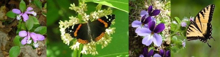
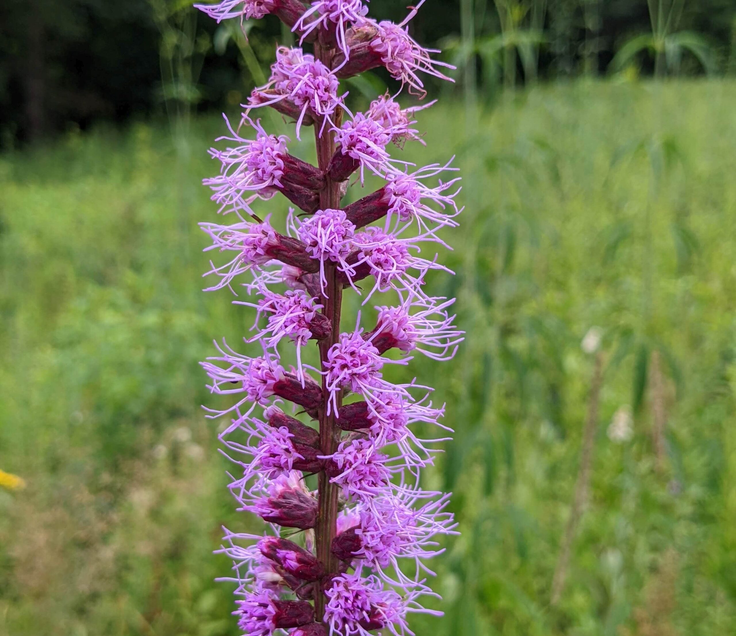
This is the perfect time to explore the relict prairie. The hot weather brings the stunning Blazing Star and some of the other dazzling summer flowers to peak performance. The goldenrods of fall will begin to show. Don’t miss the spectacular butterflies that grace the prairie with their breathtaking beauty. Flycatchers, vireos, tanagers, Common Yellowthroats and Cedar Waxwings sometimes make an appearance. We may come across a Red Eft, the larval form of a Red-spotted Newt.
Outings are free and open to the public. Bring your friends. Trails are wheelchair accessible.Wear a hat and sunscreen. Bring binoculars, field guides, water and a lunch.
Directions From Pittsburgh: take I-79 North to Exit 99, New Castle/ Butler. Drive east on Route 422 roughly 5.8 miles to the Prospect Exit. Turn left (north) onto Route 528.
Continue on Route 528 for about 7 miles. Meet in the Jennings Environmental Center Parking Lot on the left (west) side of the road.
Work Day at Fringed Gentian Fen and Plain Grove Fen Natural Areas, Lawrence County
Western Pennsylvania Conservancy is having a Volunteer Land Steward Work Day at Fringed Gentian Fen Natural Area and Plain Grove Fen Natural Area. Let’s show our appreciation for the conservation of these areas by joining them for invasive plant removal, woody vegetation control and tree-planting maintenance.
For additional information, go to: https://waterlandlife.org/volunteer/ , Select “Current Volunteer Opportunities, and the Sat., June 5 event. For questions, contact Andrew Zadnick, Director of Land Stewardship at azadnik@paconserve.org or (412) 977-9681 (cell).
We will meet at 9:00 AM along Frew Mill Road in Shenango Township.
Directions: From Pittsburgh, take I-79 North to Exit 99‑US 422. Turn left onto US 422 west and travel 7 miles. Turn right at PA 388 North and continue 1.2 miles to Frew Mill Road. Turn left onto Frew Mill Road and continue 0.7 mile.
GPS Coordinates: 40.9904, -80.28111
Sunday, June 13, 10:00 AM
South Sandy Creek in State Game Land 39, Venango County
Leader: Ron Zagrocki; Cell:( 717) 580-5736
Directions: From Pittsburgh, take I-79 north to Exit 121 for US 62 Mercer/Franklin. Turn right and continue 2 miles the point where US 62 turns to the left – but continue straight onto PA 965. Travel PA 965 for 8.5 miles to turn right onto Slatertown Road, a dirt road. Continue 2 1/4 miles to a gravel parking lot on the left. If you drive over an open-grate bridge, you’ve gone too far.
GPS coordinates: 41.29860, -79.94920
Saturday, June 19, 2021, 1:00 PM
Ferncliff Peninsula, Ohiopyle State Park, Fayette County
Directions: From Pittsburgh, take the PA Turnpike to Exit 91 – Donegal. Turn east (left) on PA 31. Travel about 2 miles and turn south (right) on PA 381. Travel ten miles to Normalville to a stop sign. Turn left onto PA 381 south and continue 11 miles to Ohiopyle. As PA 381 enters Ohiopyle, it crosses railroad tracks. Turn right just before the bridge over the Yough to enter the Ferncliff parking lot, where we will meet.
Although the state park will be crowded with enthusiastic outdoor recreationists and sightseers, the inland trails will be quiet and ideal for a wildflower hike. We may first head to another hiking trail, so if you arrive late, please call Mark at 724-454-4012 or look for a note directing you to the correct trail.
Everyone is welcome, including non-members. Trips last 3 to 4 hours but one can leave at any time. For questions, call the field trip leader or Loree Speedy at (724) 518-6022 (cell) or loreespeedy@gmail.com.
Sunday, March 28, 2021, 1:00 PM
Little Sewickley Creek at Herminie, Westmoreland County
This is a favorite trip for Snow Trillium. The walk is easy along an old railroad grade.
Directions: Take the PA Turnpike to Exit 67-Route 30/Irwin/Greensburg. Take the Route 30 East/Greensburg ramp. At the first stoplight on Route 30, turn right onto Arona Road, then another right after 0.5 mile onto unmarked Wendel Road. Travel this road 3.7 miles to a T. Turn right at the T and continue 1 mile to Herminie to a 4-way stop (VFD on corner). Continue straight to the next stop sign and turn left. Proceed through 2 more stop signs, end at a T, and turn right. Continue past the Dairy Queen on your right and continue down a hill; we will meet just before the highway bridge. Park on the left side.
These directions are difficult as roads are unmarked and state roads through Herminie sometimes look like alleys. If you can use them, the GPS coordinates will likely take you by a more direct route. GPS coordinates: 40.26050, -79.72700.
Directions: From Pittsburgh, travel PA 51 south to its junction with PA 201 (just after Bills and Willowbrook Plaza). Continuing on PA 51, travel 2 additional miles to the traffic light for Concord Ln and turn left. (This traffic light at Concord Ln can also be reached by I-70 exit 46B and continuing north on PA 51 to the northern Concord Ln intersection across from C Harper car dealership.) Traveling on Concord Ln, turn left onto Municipal Dr. Continue about 0.6 mile, pass Timm’s Ln, and turn left into the main entrance to Cedar Creek Park. Follow this road downhill, cross the bike trail, and turn left to continue through a series of parking lots until you reach the farthest parking lot, near the Gorge Trail.
GPS coordinates: 40.17830, -79.77820. (The road configuration near Concord Ln has just been modified, and GPS units and Google Maps have not yet been updated).
Directions: We will meet at the restaurant parking lot along Wildwood Road between PA Route 8 and North Park. At intersection of Wildwood Road and PA 8, head west for ½ mile to a restaurant parking lot on the left. If you are coming from North Park, the restaurant parking is on the right, 1.1 miles from the Wildwood Sports Complex.